World Transit Maps 8.0.1
Continue to app
Free Version
Publisher Description

Well-designed railway maps integrating all railways, commuter lines and metro.
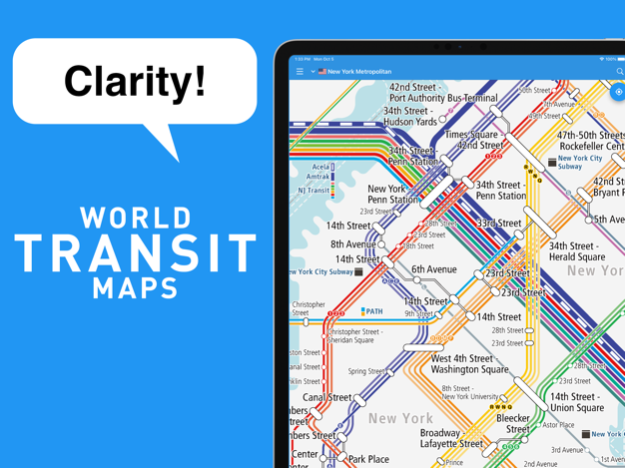
● Clarity! Railway maps
It includes all stations on all lines, such as the High-speed trains, intercity, commuter, metros, and trams with the intuitive and easy-to-understand design.
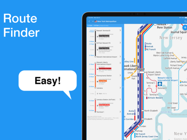
● Easy! Route finder
Tap a station on the map to add it to your route and we will propose the best route for you. Search results can be displayed at the same time as the railway map, so you won't get lost.
● Comforted! Service status
You can quickly check the service status for each line, such as suspension and delays. If you meet any troubles, you can search for an alternative route while looking at the railway map.
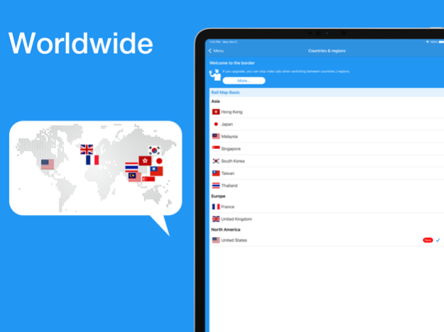
● Covering 10 countries / regions around the world
You can also see the world railway maps for free, which is useful for abroad travel. Great for finding access from the airport to the downtown and how to get between cities.
------------------------------
Countries / Regions
------------------------------
The coverage area will continue to expand steadily in the future.
[Asia]
- Hong Kong
MTR, Airport Express, Hong Kong Tram, Peak Tram, Light Rail
- Japan
Shinkansen, JR, railways
Subways in Tokyo, Yokohama, Nagoya, Kyoto, Osaka, Fukuoka etc.
- Malaysia
KTM, KLIA Express, KL Monorail, Kuala Lumpur LRT
- Singapore
MRT, LRT, Sentosa Express, cable car
- South Korea
KTX, KORAIL, Airport Express (A'REX)
Subways & metro in Seoul, Incheon, Daejeon, Daegu & Busan
- Taiwan
High-Speed Railway (HSR), Taiwan Railway (TRA), Alishan Forest Railway
Taipei & Kaohsiung Metro
- Thailand
State Railways (SRT), Airport Rail Link
BTS (Skytrain) & MRT in Bangkok
[Europe]
- United Kingdom
Eurostar, South Eastern High Speed, National Rail
Underground (Tube), metro, tram in London, Manchester, Newcastle etc.
- France
Eurostar, Thalys, TGV, Ouigo, Intercités, TER, Transilien, RER
Métro in Paris, Lille, Lyon, Marseille, Toulouse & Rennes
Tramway in Strasbourg, Mulhouse, Grenoble, Montpellier, Bordeaux, Nantes, Caen etc.
[North America]
- United States
Amtrak, Bright Line, Alaska Railroad, Metro-North Railroad, Long Island Rail Road, PATH, NJ Transit, SEPTA, Metra, New York City Subway, CTA in Chicago, RTD in Denver, Los Angeles Metro, Muni Metro in San Francisco etc.
------------------------------
Major Functions
------------------------------
- Railway maps for multiple languages
(Offline browsing is available if already downloaded)
- Transit route search
- Service status
- Street maps
- Hotel reservation
- Timetable of stations (Japan Only)
- Photo gallery of stations
------------------------------
Upgrade
------------------------------
You can now use the railway maps and the transit route search of all provided countries / regions with regardless of the free / paid plan.
“Rail Map Basic” (Free)
- You need to watch a video ad when switching between countries / regions.
- The railway maps or other screens show ads.
“Rail Map Passport” (One-time-purchase)
- Fast Lane: Video ads are not displayed when switching between countries / regions.
- The railway maps or other screens show ads.
“Rail Map Premium” (Monthly Subscription)
- Fast Lane: Video ads are not displayed when switching between countries / regions.
- Ads are disappeared on the railway maps or other screen *1.
*1 Some ads may be shown on the screen such as the result of transit route search or others.
Oct 11, 2023
Version 8.0.1
[Ver8.0.1]
- Fixed some bugs.
[Ver 8.0.0]
- Added support for the new "tile method" transit maps. There's no need to download a large file first; it loads and displays the parts of the image you need as you scroll.
- We will gradually switch from the conventional "download method" to the "tile method."
- Countries/regions that currently support the tile method: Hong Kong, Macau
- Expanded coverage area! We have started providing route maps for Macau.
- Fixed some bugs.
About World Transit Maps
World Transit Maps is a free app for iOS published in the Recreation list of apps, part of Home & Hobby.
The company that develops World Transit Maps is TOKYO STUDIO INC.. The latest version released by its developer is 8.0.1.
To install World Transit Maps on your iOS device, just click the green Continue To App button above to start the installation process. The app is listed on our website since 2023-10-11 and was downloaded 26 times. We have already checked if the download link is safe, however for your own protection we recommend that you scan the downloaded app with your antivirus. Your antivirus may detect the World Transit Maps as malware if the download link is broken.
How to install World Transit Maps on your iOS device:
- Click on the Continue To App button on our website. This will redirect you to the App Store.
- Once the World Transit Maps is shown in the iTunes listing of your iOS device, you can start its download and installation. Tap on the GET button to the right of the app to start downloading it.
- If you are not logged-in the iOS appstore app, you'll be prompted for your your Apple ID and/or password.
- After World Transit Maps is downloaded, you'll see an INSTALL button to the right. Tap on it to start the actual installation of the iOS app.
- Once installation is finished you can tap on the OPEN button to start it. Its icon will also be added to your device home screen.
